TOP
 Research
 Research Teams
 Computational Disaster Mitigation and Reduction Research Team
Computational Disaster Mitigation and Reduction Research Team
Japanese
Team Principal Hirofumi Tomita
 htomita[at]riken.jp (Lab location: Kobe)
- Please change [at] to @
- 2025
- Team Principal, Computational Disaster Mitigation and Reduction Research Team, RIKEN R-CCS (-present)
- 2011
- Team Leader, Computational ClimateScience Research Team, AICS (renamed R-CCS in 2018), RIKEN (-present)
- 2007
- Senior Scientist, Research Institute of Global Change, JAMSTEC (fka Frontier Research Center for Global Change)
- 1999
- Researcher, Frontier Research Center for Global Change (fka Frontier Research System for Global Change)
- 1999
- Graduated from Graduate school of engineering, The University of Tokyo
Keyword
- Automatic Urban Structure Modeling
- Liquefaction Simulation
- Engineering application of meteorology (communication of forecast, damage estimation, insurance)
- Simulation of Hydrology, River Discharge and Sediment Transportation
Research summary
Computational disaster mitigation and reduction research team is aimed at advancing large-scale numerical simulation for complex disasters such as earthquake, tsunami and heavy rain, targeting Kobe City and other urban areas in Hyogo Prefectures. Beside for the construction of a sophisticated urban area model and the development of new numerical codes, the unit seeks to be a bridge between Science and Local Government for the disaster mitigation and reduction.
Main research results
Hazard map based on large-scale simulations
We have developed a next-generation hazard map depicting a possible scenario resulting from the predicted Nankai Trough Earthquake. Using large-scale numerical simulations, the map includes four cities in Hyogo prefecture.
Previously, hazard maps were made from the results of simpler numerical simulations and empirical equations based on distribution of ground motion index values. However, the latest simulations using the K computer for next-generation hazard maps have simulated propagation and amplification of seismic waves, and then calculated their physical impact on buildings. In other words, the latest simulations have explicitly calculated the fragility curve. This calculation is an essential component for estimating damage to cities caused by earthquakes because the simulation includes the elemental physical process of the propagation of waves and the response of buildings to these waves. We are applying it to the other disasters like floods, landslides and mud slides; and we will estimate the propagation of the disaster impact into traffic and economy.
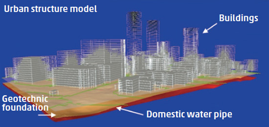
Our numerical simulation developed to create next-generation hazard maps has two advanced features. The first is the comprehensive simulation of an entire city 100km2 in area. Comprehensive simulation means both geotechnical wave propagation and urban structures to be simulated simultaneously. This large-scale comprehensive calculation has been performed on the K computer.Consequently, this research achievement in the computational science had been chosen as a finalist for the Gordon Bell Prize. It is much more expected with Fugaku in the near future. The second feature enables the technology to represent existing buildings in numerical simulations as data and equations. By using newly developed data processing platform, hundreds of thousands of buildings can be represented in such simulations.

Representative papers
-
Yokoya, N., Yamanoi K., He, W., Baier, G., Adriano, B., Miura, H., Oishi, S.:
“Breaking the Limits of Remote Sensing by Simulation and Deep Learning for Flood and Debris Flow Mapping”
in IEEE Transactions on Geoscience and Remote Sensing, vol.60, pp. 1-15, (2022). -
Takeyama, T., O-tani, H., Oishi, S., Hori, M., Iizuka, A.:
“Automatic construction of three-dimensional ground model by data processing” in IEEE/ASME Transactions on Mechatronics, vol.26, no.6, 2881-2887, (2021).
-
Yamanoi, K., Oishi, S., Kawaike, K., Nakagawa, H.:
“Predictive Simulation of Concurrent Debris Flow: How Slope Failure Locations Affect Predicted Damage”
Journal of Flood Risk Management, (2021). -
Chen J., Takeyama, T., O-tani, H., Yamanoi, K., Oishi, S., Hori, M.:
“Code verification of soil dynamics simulations: A case study using the method of numerically manufactured solutions”
Computers and Geotechnics, Vol.117, (2019), (https://doi.org/10.1016/j.compgeo.2019.103258). -
Chen J., O-tani, H., Takeyama, T., Oishi, S., Hori, M.:
“Toward a numerical-simulation-based liquefaction hazard assessment for urban regions using high-performance computing”
Engineering Geology, Vol.258, (2019), (https://doi.org/10.1016/j.enggeo.2019.105153). -
Chen J., Takeyama, T., O-tani, Fujita, K., Motoyama, H., Hori, M.:
“Using High Performance Computing for Liquefaction Hazard Assessment with Statistical Soil Models”
International Journal of Computational Methods, Vol. 16, p.1840005(1-21), (2019), (https://doi.org/10.1142/S0219876218400054). -
Maddegedara, L., Gill, A., Poledna, S., Hori, M., Inoue H., Noda T., Toda K., and Ichimura T.:
“Distributed Memory Parallel Implementation of Agent Based Economic Models”
Lecture Notes in Computer Science, (2019). -
Fujita, K., Horikoshi, M., Ichimura, T., Meadows, L., Nakajima, K., Hori, M., Maddegedara, L.:
“Development of Element-by-Element Kernel Algorithms in Unstructured Implicit Low-Order Finite-Element Earthquake Simulation for Many-Core Wide-SIMD CPUs.”
Computational Science - ICCS 2019, Lecture Notes in Computer Science, vol 11536, (2019). -
Hori, M., Ichimura, T., Wijerathne, L., Ohtani, H., Chen, J., Fujita, K., Motoyama, H.:
“Application of High Performance Computing to Earthquake Hazard and Disaster Estimation in Urban Area”
Front. Built Environ., (2018). -
O-tani, H., Hori, M., Wijerathne, L.:
“Automated Model Construction for Seismic Disaster Assessment of Pipeline Network in Wide Urban Area”
Earthquakes, Intech, (2018).
